
Page 3 - tmp
P. 3
Geophysical Surveys at Archaeological site near Krušik stadium in Valjevo
Borko Rajović
Military Grammar School, Belgrade, borko.rajovic@gmail.com
Introduction
Geophysical survey in archeology are increasingly
implement. Each geophysical method provides information
about a particular physical feature of subsurface. By
integrating these data, provide complete information to
determine the possibility of archaeological remains in the
ground. Archaeological site on which geophysical survey is
conduct, represents the remains of a medieval monastery
Gradac and is located in the town of Valjevo. The task of
research is to determine the differences in electrical
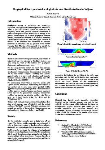
resistance of subsurface and the gradient of the Earth's Figure 1: Resitivity anomaly map at 2m depth interval
magnetic field. The aim of the research is to identify the
areas whit possible existence of archaeological remains.
Methods
Figure2: Resistivity profile P1
Based on previous archaeological research, area 20x20m is
determined near the entrance to Krušikov stadium, and
area along the wall of the stadium, for geophysical
electrometry and magnetometry survey.
For the magnetometry survey, we used Gem Systems
Overhauser GSM magnetometer with two probes
(gradiometer). Magnetometry data acquisition was carried Figure 3: Resistivity profile P2
out in area 20x20. Magnetic profiling was oriented
approximately in a north-south direction, and opposite. Anomalies that indicate the provision of the walls were
Distance between profiles was 1m, sampling was 0,5m determined, and the third profile located near a perimeter
(Starčević i Đorđević 1999.). wall of the stadium, where on the other side remains of the
church are found. Results of the magnetometry
For electrometry suvery Wenner array was applied with measurements are partially correlated with electrometrical
Lipman 4points instrument. Electrometry data acquisition data, however, in order to eliminate noise in the signal, they
was carried out in same area within parallel profiles need to be further filtered and processed.
applying mapping and profiling technic. Distance between
profiles was 2m, spacing between geoelectric measuring
points was 2m, for geoelectrical mapping. Geoelectrical Conclusion
profiling was carried out at three profiles, with Wenner
array, at 4 depth levels, 0,5m, 1m, 1,5m and 2m
(Vukadinović 2011). Obtained data showed certain anomalies. Anomalies
Cabinet work included the processing of the obtained data, identified on the resistivity anomaly map and the two
after which anomaly map of resistivity and the vertical resistivity profiles match, which indicates that there are
gradient of the Earth's magnetic field at the target area were archaeological remains. However, this resultts do not
created, and profiles of the resistivity. Data processing was coincide completely with anomalies obtained with
performed using the program Surfer 11 and Res2D. magnetometry survey. In addition, anomalies in the third
profile indicate the existence of the remains of the church
outside the currently known site area.
Results
On the resistivitay anomaly map in-depth level of two References
meters (Fig. 1) two positive anomalies were observed. In
order to determine the cause of the observed anomalies we 1. Starčevič M. i Đorđević A. (1998) Osnovi
conducted two resistivity profiles, across these anomalies. geofizike II Gravimetrijske i geomagnetske
Profiling results confirmed the existence of archaeological metode, Univerzitet u Beogradu
objects in zones of maximum value resistivity anomaly map 2. Vukadinović M. (2011), Primena geofizike u
(Fig. 2 and 3). Based on previous archaeological findings, it arheologiji, Zavod za zaštitu spomenika kulture
is assumed that it is a stone tombs. However, in order to Kraljevo, Narodni muzej Kraljevo
determine the exact causes of these anomalies, need further
archaeological research